
JUMP TO: Road closures
JUMP TO: One fatality in Deltona
Scenes around Volusia County this afternoon as Hurricane Ian heads north

BLOCKED OFF — A downed tree blocks the road near the intersection of North Clara and University avenues.
VIDEO BY KEVIN AVILES
A canal at an intersection in Deltona overflows, washing out the road. In the middle of it all was one of Aviles’ neighbors. He said with some help, he was able to get them to safety. “Our neighbor helped her get out through the passenger seat,” he said. “All the neighbors rushed out to help her as soon as we noticed”
VIDEO BY KHRISTINA PRESTON JEFFORD
A split tree in Lake Helen.

A snapped power pole on Summit Ave. in Lake Helen.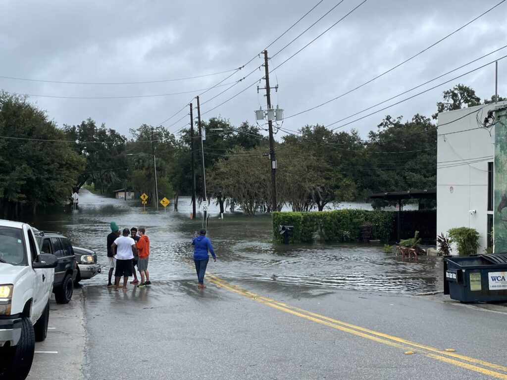
WATERLOGGED — Downtown DeLand, near the intersection of Wisconsin Avenue and North Woodland Boulevard, floods with rainwater from Tropical Storm Ian in this photo from Beacon reader Matthew Manchester taken around 1 p.m. Sept. 29. Much of Downtown DeLand lost power due to the storm’s strong winds and torrential rain.
3:30 P.M. SEPT. 29:
Volusia County: Tail end of historic storm; It may seem calmer, but stay off the roads
Volusia County officials addressed the state of the county after hours of heavy winds and rain have battered the area.

DOWNED — DeLand resident Rocky Fearon, who lives on the 100 block of West Ohio Avenue near Downtown DeLand, surveys the damage a fallen tree did to his home. The tree came crashing down around 7 a.m. Sept. 29. Resulting from storm damage, Fearon has leaks in four rooms of his home.
“To give you some perspective on the magnitude of this storm, a 100-year storm event is roughly 11 inches of rain over a 24-hour period,” Volusia County Public Works Director Ben Bartlett said. “Hurricane Ian has just dropped more than double that amount, across Volusia County.”
As of 3 p.m. Sept. 29, some 247,000 Volusia County households and businesses — roughly 80 percent of all utility customers in the county — were reported to be without power.
In the aftermath of the storm, county officials said the county will work with the American Red Cross and other community partners to ensure people have a safe place to stay.
But the aftermath of the storm isn’t here quite yet.
“[W]e’re not out of the woods, and we’re still on the tail end of the storm, and high water still looms over many roads making driving conditions impossible or extremely dangerous,” Volusia County Communications Director Kevin Capitan said. “We continue to stress the message please stay off the roads until further notice.”
More rainfall is anticipated on an already “very saturated county,” Volusia County Interim Emergency Management Director Jim Judge said.

STRUNG UP — A downed branch took a few power lines with it in this photo from Pierson.
The tropical storm’s eye has moved east off of Florida’s coast and is expected to turn north before the day is out. After Ian pivots north, the storm is expected to strengthen back to a hurricane before it approaches North and South Carolina late Friday night, Sept. 30.
“Strong winds on the western periphery of the storm continue to produce dangerous conditions across portions of east central Florida, particularly over Brevard and Volusia counties, where hurricane force wind gusts cannot be ruled out for the next several hours,” a 3 p.m. bulletin from the National Hurricane Center said.
“Strong winds on the western periphery of the storm continue to produce dangerous conditions across portions of east central Florida, particularly over Brevard and Volusia counties, where hurricane force wind gusts cannot be ruled out for the next several hours,” a 3 p.m. bulletin from the National Hurricane Center said.
The heaviest rainfall is expected to be behind Volusia County, but several more inches could still fall. Meanwhile, the risk of tornadoes associated with Hurricane Ian has passed.
SEPT. 29 1:30 P.M.
Cities across the county report water problems
Power outages and other storm-related problems with water systems were reported across West Volusia Sept. 29.
Around 12:30 p.m. Sept. 29 the City of Deltona reported a water main on West Portillo Drive broke. The road is not closed as of 1 p.m., but the city will install signs if the road needs to be shut down for maintenance.
In Orange City and DeLand, cities are asking residents to limit water usage to help avoid the risk of overflowing the sewer system.
“During heavy rain events and/or power outages, we recommend customers limit laundry, showering, dishwashing, flushing, and other activities that contribute to sewer flows,” Orange City officials said in a social media post. “Water should only be used for essential functions.”
In DeLand, city water customers are asked to conserve water for the next 48 hours.
In Pierson, homes and businesses began to lose electricity not long after Ian’s effects were felt Sept. 28. Around 3 a.m. Sept. 29, the generator powering the city’s water well ran out of power, and the town is in the process of getting a new generator to get the water system back up and running.
Meanwhile, as Ian continues to pass by Volusia County, flood advisories remain in place.
According to the National Hurricane Center, “Between 10 and 15 inches of rain have fallen, with localized totals up to 20 inches in Volusia County.”
As of 2 p.m., nearly 80 percent of Volusia County is without power, affecting some 247,312 customers.
WATERLOGGED — Downtown DeLand, near the intersection of Wisconsin Avenue and North Woodland Boulevard, floods with rainwater from Tropical Storm Ian in this photo from Beacon reader Matthew Manchester taken around 1 p.m. Sept. 29. Much of Downtown DeLand lost power due to the storm’s strong winds and torrential rain.
SEPT 29 12 P.M.:
Large Tropical Storm Ian projected to become a hurricane again, will affect Volusia for days
Moving around 9 mph, according to the National Hurricane Center, tropical storm Ian is expected to travel east back into the Atlantic Ocean and then hook to the north later today, Sept. 29.
According to the latest NHC bulletin at 11 a.m., because the storm has jogged eastward more than expected over the Atlantic Ocean, it is expected to strengthen after it leaves Florida’s east coast, becoming a hurricane once more.
As of around 11:30 a.m., Ian was located around 54 miles west-southwest of Deltona.
While the storm will not be as close to Volusia County, wind, rain and flooding are expected to continue through the weekend and into next week. Ian has also expanded, bringing tropical-storm-force winds outward up to 415 miles from the eye.
In Volusia County, as of around 12 p.m., wind gusts are projected between 58 and 73 mph, with sustained winds around 40 mph. The NHC also projects that the condition is favorable for tornadoes.
The St. Johns River, already dealing with flooding, is expected to approach record heights of 4.6 feet later tonight and then begin descending.
Per the National Hurricane Center, “Interests along the river should be prepared for major flood impacts to arrive today and tonight.”
A flood watch remains in effect in inland Volusia County.
Stay home!
Like all hurricanes, Ian is a lopsided storm, with one side that extends further from the eye. As Ian continues its counterclockwise rotation, this longer section will continue to pass over Volusia County Thursday and into Friday, and its strong spiraling rain bands can come with gusts of wind around 40 mph and up to 70 mph.
Because one side of Ian does not extend as far, as the storm moves away from Volusia there will be brief moments where the weather appears to have improved.
Do not attempt to pick up yard debris at this time, as the calmer weather is fleeting.
Ian has expanded, and tropical-force winds now extend up to 445 miles from the center.
Additionally, a tornado or two remains possible over Volusia and northern Brevard counties, although the threat will decrease throughout the day as Ian moves further offshore.

Tropical storm Ian pictured from satellite imagery around 11:30 a.m. Sept. 29
SEPT. 29 10:30 A.M.:
Volusia County urges people to stay home as Ian continues to unleash ‘historic’ rains

Volusia County Interim Emergency Management Director Jim Judge said to expect the heavy wind and rain from tropical storm Ian to continue for at least the next six hours during a 10 a.m. press conference Sept. 29.
Key takeaways:
— Volusia County has extended last night’s curfew from now, 10 a.m. Thursday, Sept. 29, until 7 a.m. tomorrow morning.
— Sustained tropical storm force wind and rain is expected for at least the next six hours, but tropical storm force gusts are expected through Sunday, Oct. 2.
— People are strongly urged to remain off of the roads and indoors.
— Flooding and other damage can be reported to the Volusia County Citizens Information Center at 866-345-0345. Power outages can be reported to power companies.
— Volusia County has one fatality
Now a tropical storm, Ian continues to batter Volusia County, unleashing historic levels of rain across the county. Volusia County officials provided an update on the storm at 10 a.m. Sept. 29.
With flooding and downed trees and power lines widespread across the county, officials practically beg people to stay indoors.
“I need people to stay off the road,” Sheriff Mike Chitwood said. “I’m imploring you to stay off of the roads. Let us do our job.”
Tropical storm-force wind and rain are expected to continue through at least the next six hours, but even as Ian moves away from Volusia County, heavy gusts are expected through Sunday, Volusia County’s Interim Emergency Management Director Jim Judge said.
“If you want to report that you’ve got a situation with water in your home — and we’re getting a lot of those calls — call the Citizen’s Information Center and report that to them and we will capture that information,” Judge said. “In a critical life threatening emergency you can contact 911 and they will log that information in.”
The Citizens Information Center can be reached at 866-345-0345, and more information about reporting damages, flooding and power outages can be found on Volusia County’s website, HERE.
If you see a downed line, assume that it’s electrified and don’t touch it or go near it. Report it to your power company as well as the Citizens Information Center at 866-345-0345.
To report power outages, please contact your electric provider:
— FPL: www.fpl.com, 800-468-8243
— Duke Energy: www.duke-energy.com, 800-228-8485
— New Smyrna Beach Utilities Commission: www.ucnsb.org, 386-427-1366
— Clay Electric: www.clayelectric.com, 888-434-9844
To watch the full Volusia County press conference, click HERE.
SEPT. 29 10 A.M.: The DeLand Fire Department reports significant flooding in Earl Brown Park and asks residents to stay in place.
Ian downgraded to tropical storm, advisories still in place
Downgraded early this morning, Ian is now a tropical storm. According to the National Hurricane Center, Ian is expected to continue east and go offshore later today, Sept. 29.
Tropical storm advisories remain in place across Volusia County and in neighboring Lake, Seminole and Orange counties.
With torrential rain and winds greater than 65 mph reported, people are still encouraged to stay inside and off of the roads.
“A tornado or two will be possible over Volusia and northern Brevard counties early this morning, with the threat decreasing this afternoon as the center of Ian moves offshore into the Atlantic,” according to a bulletin from the National Hurricane Center.
Nearly 40 percent of Volusia County is believed to be without power.
On the other side of the state, Lee and Charlotte counties, per Florida Gov. DeSantis this morning, are “basically off the grid at this point.” The governor estimates the storm has led to “hundreds of fatalities.”
Bridges across Volusia County remain closed due to strong winds.
The full 5 a.m. update from the National Hurricane Center is available to read HERE.

Man found dead in Deltona
According to the Volusia County Sheriffs Office, a man was found dead, believed to be drowned, outside of his Deltona home around 1 a.m. this morning.
“Deputies responded to a home on Poinciana Lane near Lake Bethel around 1 a.m. after the victim’s wife reported he disappeared after heading outside,” the Sheriffs Office said.
The victim was found unresponsive in a canal outside of his home, the sheriffs office said, and he was later pronounced dead at the hospital.
Deputies believe the individual had gone outside to drain his pool when he slipped on the wet ground.
DeLand warns of strong winds to come
The City of DeLand reported on social media this morning that most of the city’s facilities are on generator power thanks to citywide power outages.
As of 8 a.m., the city’s curfew has been lifted, but people are urged to stay indoors.
“We will also be experiencing our strongest winds over the next few hours as Ian moves offshore,” a post on Facebook from the city said. “It’s going to be a long day. Hang in there, DeLand.”
For yesterday’s updates about Ian, click HERE.
Many roads closed, people urged to stay sheltered
Dangerous weather conditions have forced roads across Volusia County to close. While people are strongly urged to stay inside and off the roads, here are roads to avoid if you have to go out.
Check map above for latest updates!
Pierson
-
South Center Street at Hagstrom Road
DeLeon Springs
-
Reynolds Road at Horseshoe Bend
-
East Berlin Street at Dundee Avenue
-
Marsh Road at Daugharty Road
DeLand
-
East Minnesota Avenue from Deanna Court to Landress Lane
-
North Boston Avenue north of East Minnesota Avenue
-
East Minnesota Avenue at North Kentucky Avenue
-
Cass Street at West Euclid Avenue
-
South Hill Avenue near East New York Avenue
-
South Clara Avenue near West Beresford Avenue, West Hubbard Avenue and further south near West Chippola Avenue
-
West Winnemissett Avenue at South Adele Avenue and South Florida Avenue
-
West Beresford Avenue at South Stone Street and near Sherwood Drive, as well as near South Spanish Lane
-
Golf Club Drive near Deerfoot Road
-
Manor View Lane inside of the Victoria Park neighborhood
Orange City
-
East Graves Avenue near Monastery Road
DeBary
-
Lakeshore Drive and Enterprise Osteen Road along Lake Monroe

