This is the first part of a series.
Why did we have flooding where we’ve never seen it before? Is it because of new developments? When will low-lying areas dry out? Will development laws change to prevent this going forward? Our series addresses the many questions Ian and Nicole left us asking.

ON ALL SIDES — This series of maps collected from Google Earth shows the area surrounding Common Ground Farm at 1330 E. Taylor Road, as indicated by the red pin, in 1999, 2004, 2010, 2016 and 2022. Various regulatory agencies and Volusia County said that development surrounding Common Ground Farm did not necessarily contribute to the flooding its owners experienced after hurricanes Ian and Nicole. Farm owners Pat and John Joslin said the surrounding development has impacted their land’s ability to drain water, but county officials said all developments have met strict stormwater regulations.
Officials say the answers lie in many variables
The 2022 Atlantic hurricane season was a rough one for Florida and Volusia County. Hurricane Ian brought as much as 21 inches of rain and nearly 100-mph wind gusts to parts of Volusia County at the end of September.
Then, a little more than a month later, Hurricane Nicole battered the county’s east coast with high waves and heavy rainfall.
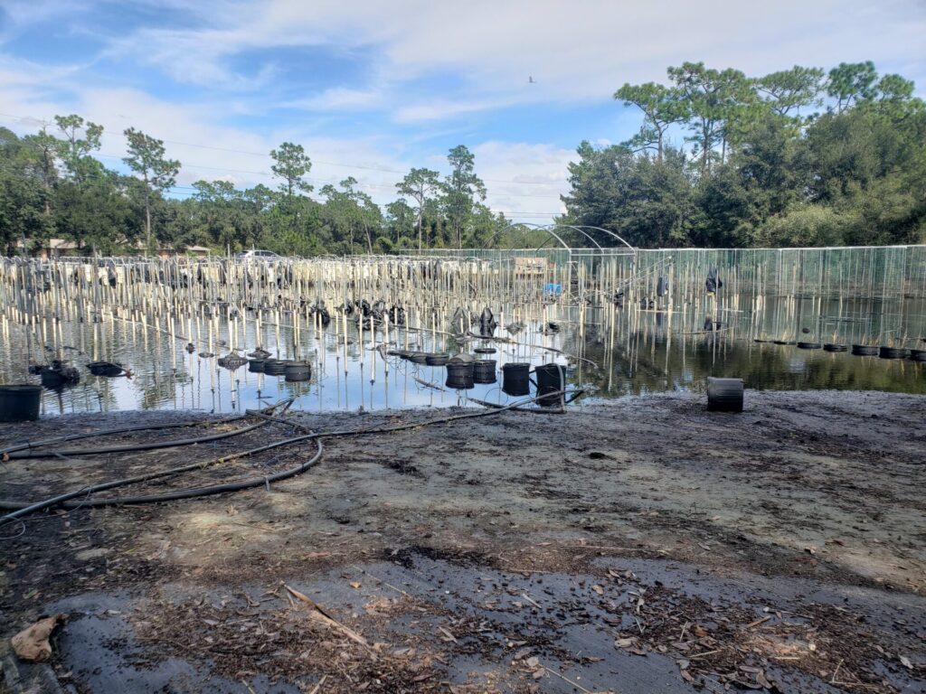
After Ian blew across Florida, Common Ground Farm owners Pat and John Joslin were surrounded by a moat about 3 feet deep.
“We could not get off the property except in my pickup,” John Joslin said.
Their farm at 1330 E. Taylor Road in DeLand grows around 20,000 pounds of fruits and vegetables a year, but flooding caused by the
500-year storm inundated more than half of their crops, the worst they’ve seen, the Joslins said. Some of the vegetables were just weeks from harvest.
In October, when the Joslins were pumping water dumped by Ian off of their property, they hoped they might turn a profit in 2023. But by December, after Nicole had refilled their property with water, the Joslins were less optimistic.
The Joslins weren’t alone in suffering damage. According to Volusia County, the two storms caused at least $858 million of damage across the county.
So what’s to blame for the unprecedented flooding in the wake of Hurricane Ian? Development? Climate change? Or is it a combination of too many variables to count?
UNDERWATER — One of the fields at Common Ground Farm on East Taylor Road in DeLand is inundated after Hurricane Ian, killing tons of crops.
Dirt doesn’t lie
David Griffis said the past can give clues to the future.
Griffis is a soil expert who used to head the University of Florida Agricultural Extension in Volusia County, and now teaches environmental science at Stetson University.
Griffis said the telltale signs of flooding can be identified even if soil has been dry for years. “Soils don’t lie; they tell us what to look for,” he said. “It may not be wet today, or tomorrow, or six months from now, or a year from now, but history shows us the soil gets wet.”
“That was a difficult thing to explain to developers, landowners and politicians,” Griffis added.
Geology meets government
Although areas like DeLand, for example, are on a geological ridge formed about 100,000 years ago, known as the DeLand Ridge, much of Florida development is built on wetlands.
For the Joslins, a lot has changed in the nearly 20 years since they started working on the Taylor Road property, and they blame the surrounding large housing developments for diverting extra water in their direction. Water was rushed into their property during and after the hurricanes, pouring from neighboring vacant lots and large housing developments like Sawyer’s Landing and Victoria Trails.
But Volusia County says neighboring, existing properties are taken into account when new developments are approved.
“When new developments come in, there are pretty stringent rules that they’re required to follow,” County Engineer Tadd Kasbeer told The Beacon. “One of those things is taking a look at the adjacent properties. We’re not doing this in a vacuum.”
Because of stormwater regulations, if there’s water pouring off a given property onto another one, water was flowing that way before any development occurred. If it causes flooding, that’s because there was a once-every-500-year storm, not because there was development, county officials said.
Many newer developments, Kasbeer said, fared well after Ian and Nicole, and that’s because standards for stormwater management imposed by the county and the St. Johns River Water Management District have become stricter over the years.
A few ‘simple’ rules
In essence, stormwater requirements for any development follows a few simple rules: The retention ponds on a property have to accommodate the same amount of rainwater as the land accommodated before development, and the development is not allowed to force more water than before onto neighboring properties.

UNPRECEDENTED — Hurricanes Ian and Nicole caused unprecedented flooding in parts of Deltona, like this on Captain Drive, photographed shortly after Ian’s visit.
“The goal is to preserve the existing conditions,” land-use attorney Mark Watts of Cobb Cole said. “If water runs off of your property, then it can continue to run off of your property, but when you develop it, you can’t increase the rate or the volume that runs off your property.”
But the amount of water rushing from one parcel of land to another is a lot different during a 100-year storm compared to a 500-year storm. And the required systems are designed to work properly in a 100-year storm — the size and strength of which has a one-in-100 chance of happening.
Ian was a 500-year storm.
“You’re exceeding design capacities,” Watts said.
Many areas that experienced flooding after Ian and Nicole weren’t built to withstand 500 year storm events. In fact, no one’s home really was.
Ian, Nicole, and big, bad storms
“What we had with Ian was nothing short of monumental,” Kasbeer said.
Ian dumped as much as 20 inches of rain on parts of Volusia County.
“We design things for the 100-year [storm] at most,” Kasbeer explained, “the idea being anything larger than that, you’re going to put a lot of effort into something that has a small chance of occurring, and in this case, it occurred.”
Soil expert Griffis said the same; building for storms like Ian just isn’t done.

PUMPING — The swales along Taylor Road are full in front of Common Ground Farm in DeLand. A blue pipe carries water from the soaked farm property into the swales, courtesy of a pump the Joslins had to set up after hurricanes Ian and Nicole.
“It would be very difficult to develop a new subdivision based on a 500-year storm,” he said. “ There would be no land left if you were trying to put in a subdivision and trying to store all of that water on site.”
The last big change to the county’s regulations occurred after the 2004 hurricane season. Before that, developments were built to withstand only 25-year storm events, Kasbeer said.
Since newer developments avoided major flooding, Kasbeer added, the county does not currently anticipate any sweeping changes to regulations in a post-Ian and post-Nicole world.
What’s not yet clear, though, is whether events that previously had a 1 in 500 chance of occurring annually are happening more often.
Climate change
The evidence does suggest that storms are dumping more water on the areas they hit.
“These extreme flooding events are becoming more common and even more severe because of a warmer and moister atmosphere from climate change,” Florida State University researcher David Zierden said. “That’s pretty much accepted by the broad community. There’s been lots of work on it, and Florida is certainly part of it.”
Zierden is Florida’s state climatologist, a position that makes him one of the foremost authorities on climate in Florida.
Sea-level rise isn’t helping, either.

LINE OF DEFENSE — John Joslin points to sandbags lined up defensively along the eastern boundary of Common Grounds Farm, where he and his wife saw water flowing onto their property from vacant land to the east of them. The Joslins would like Volusia County to buy the vacant parcel and turn it into a stormwater-retention area.
“The seas have risen about approaching 1 foot in the last 100 years, which seems like a very slow rise, but if you add another foot of sea-level rise, it can really exacerbate the erosion problems,” Zierden added. “I think we’re seeing the combination of all of that.”
With all of those variables in mind, Volusia County argues that there’s much more going on than added development causing worsened flooding.
“With global warming and climate change, we already have the evidence to anticipate that the storms are getting bigger,” Volusia County Community Information Director Kevin Captain said. “Emergency management, their key thing is mitigation.”
The county has received grant money to invest in creating low-impact-development standards for stormwater infrastructure, as well as grants of $288,000 and $440,000 to conduct vulnerability assessments across the county.
The assessments would better help the county understand how sea-level rise and other factors will affect critical infrastructure.
Next up in our series: The beach, and will development rules change?
Thinking of buying property?
Check this map first to see if it’s flood-prone
While it may look dry when you buy a house or select land to build a home, Florida is a wet state, and much of the state is made up of historic wetlands.
That’s why Volusia County is urging prospective homebuyers and landowners to take a look at the history of the land they are considering for purchase.
“Hopefully this storm reinforces how important it is prior to buying a piece of property to do the research to find out what the water levels were on that property in the past,” County Engineer Tadd Kasbeer told The Beacon. “I can’t emphasize that enough: Do your due diligence before you buy a property or build on a piece of property.”
County officials urged people to go to the county’s website to take a look at interactive maps that show areas at risk of flooding and more.


I understand the state does have a law that says “ no developement will cause harm to neighboring properties! Yet they continue to flood us out with huge 3000 house developements